
Marine and Airborne Magnetics
Magnetic surveys are most economically conducted in conjunction with seismic acquisition.
In general magnetic data has often been acquired in areas where it would enhance the geological interpretation.
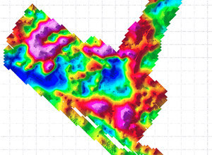
Marine magnetometer data contains important geological information such as the thickness of sediments, the locations of faults, and the aerial extent of volcanic rocks. In frontier exploration areas marine magnetic and gravity data are often combined to provide a low cost regional exploration tool for the delineation of large basins prior to conducting expensive seismic surveys. In more mature exploration environments marine magnetic data are often combined with gravity, seismic and well log data to generate an integrated geophysical interpretation of the prospect.
When acquiring magnetic data over a long time period, absolute accuracy becomes very important.
GRAVIONIC uses mainly Overhauser magnetometers and optically pumped caesium vapour magnetometers. Whenever the highest resolution and/or sampling rate for measurement of the earth's magnetic field is required, caesium vapour magnetometers are the most widely used types, both for surveys and for base stations. The typical performance of an optical pumped caesium vapour magnetometer is an absolut accuracy of < 3 nT and sampling rates from 2 to 10 Hz over a range of 20,000 to 100,000 nT. The advantage of Overhauser magnetometers is that they do not drift due to effects such as temperature, time, or even magnetic heading (e.g. the SeaSpy system).
GRAVIONIC offers high resolution and high sensitivity at fast sample rates in combination with high-precision navigation and positioning.
When combined with gravimetric data, magnetometry improves the interpretation of the seismic data. Furthermore, the combination delivers valuable information for pilot surveys.
Gravionic GmbH
Hermann-Blenk-Str. 27+29
38108 Braunschweig
Germany
Phone: +49 531 26 25 18 4
Mobile: +49 172 8777183
E-Mail: service@gravionic.de